 Faculty of Art
KANAYA Masataka
Hōsei University
Tōkyō Gōshō Sugoroku. Source: University of British Columbia. Library. Rare Books and Special Collections. Asian Rare-6 no.L3:1.
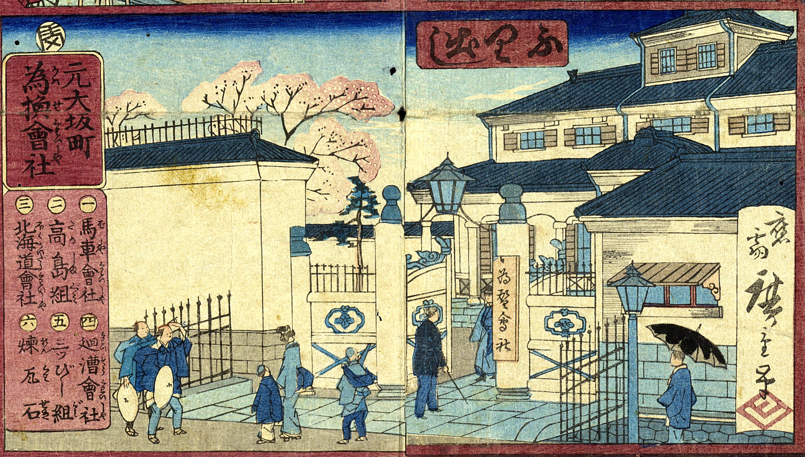 Fig.1: Detail of Kawase Gaisha in Tōkyō gōshō sugoroku (Click here to enlarge). | 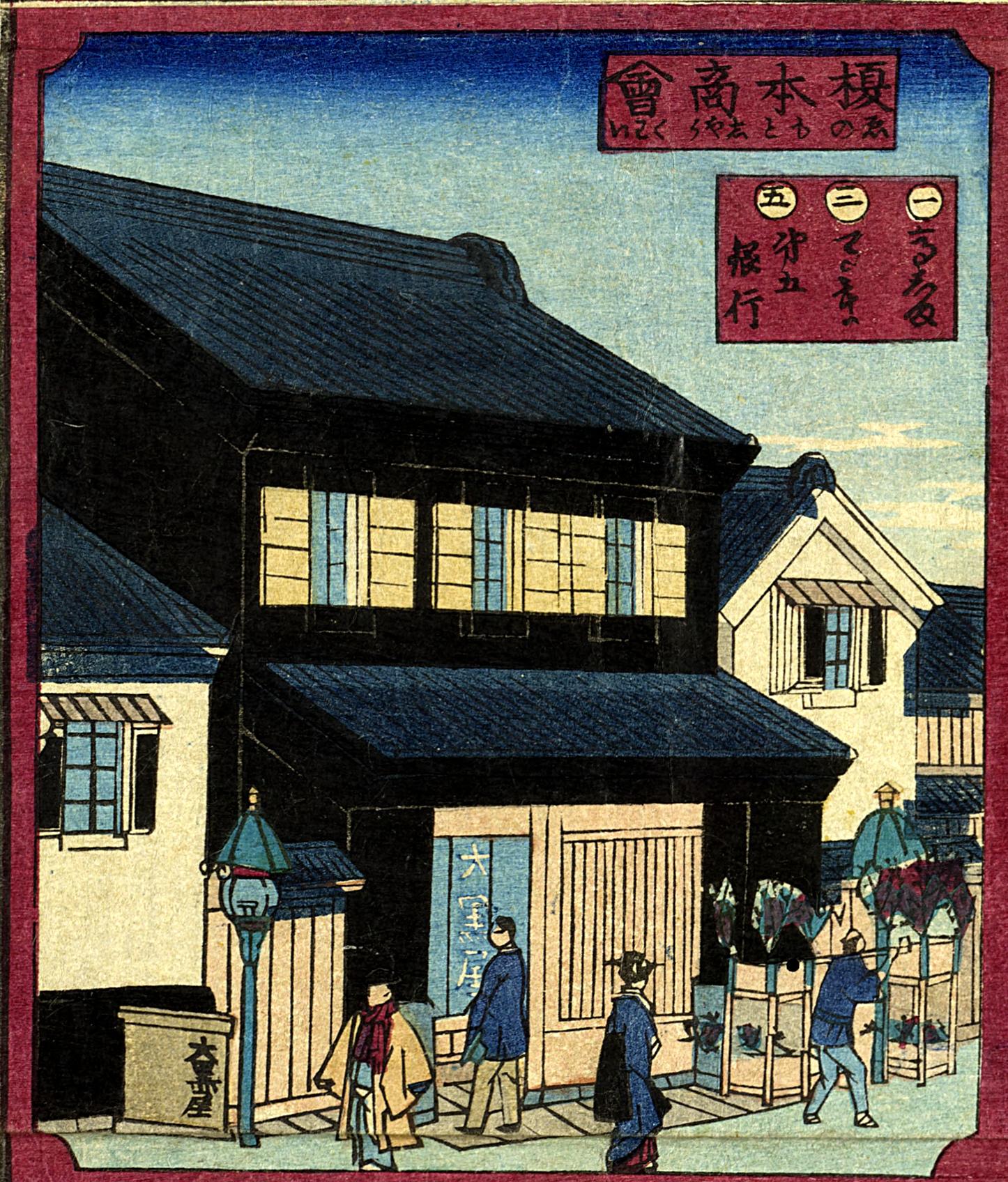 Fig. 2: Detail of Enomoto Shōkai in Tōkyō gōshō sugoroku. |
First, a detailed look at the Tōkyō Gōshō Sugoroku. In each of the game squares, we can see a number of building types no longer present in Tokyo – castellated buildings, roofs adorned with mythical sea creatures (shachi), or the plastered warehouses and Western-style brick buildings lining the Ginza. Labels identify the names and addresses of companies new to Tokyo at the time. Starting from the Kawase Gaisha commercial exchange in the bottom-central furidashi square, players roll the dice to reach the First National Bank in the agari square at the top-center. Notice the label in the Kawase Gaisha square locating the building in Moto-Ōsakachō (Fig. 1), a commoners’ neighborhood from the Edo-period that disappeared in 1933 as part of the Imperial Capital Reconstruction Project following the Great Kantō Earthquake (now part of Nihonbashi Ningyōchō). A number of theories exist for the origin of the neighborhood’s name, but it is thought it derives from the granting of the land to merchants who moved from Ōsaka during the Tenshō Era (1573-1592), with “Moto” added to distinguish the area from nearby Shin-Ōsakachō (now Nihonbashi Tomizawachō). [3] During the Edo Period, the urban space of Edo was made up primarily of samurai areas (bukechi), commoner areas (chōninchi), and temple and shrine lands (jishachi). According to an 1869 survey, bukechi made up 68.6%, or 9,585 acres, of the urban area of Edo, with the remainder split evenly between chōninchi (15.8%) and jishachi (15.6%). [4] It is possible, moreover, to roughly define a typical pattern of buildings that would have stood in each of these areas.
To this point, notice the layout of the buildings. Following the precedent of Edo-period samurai areas, the buildings are set far back from the street-front gate, allowing the gate to completely obscure the front entrance of the building. Bukechi lands were granted exclusively to warriors by the Tokuagawa Shogunate and varied in size, but most followed the basic layout of gradual stages passing from the street through a main gate into the compound and to a special guest entrance into the residence. In Edo commoners’ areas, on the other hand, storefronts faced directly onto the street with no gates, allowing direct entry into the building. On the Tōkyō Gōshō Sugoroku, both the Enomoto Kaisha and the Kajima Sakadana are of this type. In this way, by looking at the layout of buildings, it is possible to define a typical pattern of Edo-period compounds. But this would mean that in the case of the Kawase Gaisha a building with a bukechi layout was erected in a former chōninchi lot.
Now, why is it that the Kawase Gaisha has a bukechi layout in the commoners’ area of Moto-Ōsakachō? In fact, this neighborhood had originally been a bukechi. In the detail of the 1874 Tōkyō Zenzu in Figure 3, we can see a marker for Tōkyō Kawase Gaisha in the centre-upper right in a plot that is quite large compared to the neighboring properties. In reality, the Tōkyō Kawase Gaisha was not in Moto-Ōsakachō at all, but instead in the 2-chōme block of Kakigarachō. Next let’s take a look at the 1859 Owariya kiriezu in Figure 4, depicting the areas to the south of those seen in Figure 3. On this kiriezu, we see the name “Ginza” denoting the location of the silver mint later replaced by the Tōkyō Kawase Gaisha during the Meiji Period. The reason the district known as Ginza today is located to the southwest of the “Ginza” shown in Figure 4 is that the mint had been relocated to this area in 1800 as a result of worsening management and incidents of illegal activity. [5] At this time, the mint was under the direct control of the Tokugawa Shogunate’s finance magistrate (kanjō bugyō). The whole of Moto-Ōsakachō and the areas across the street were all bukechi with many Daimyō compounds. During the Edo period, bukechi neighborhoods did not have names, and the name Kakigarachō was not fixed until the tenth month of 1871. [6]
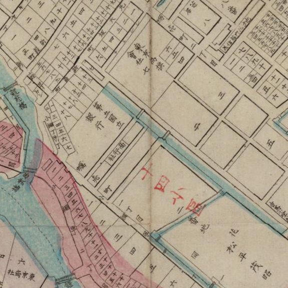 Fig. 3: Tōkyō zenzu (1875) Original Format: University of British Columbia. Library. Rare Books and Special Collections. G7964 .T7 1875 I3 (Click to enlarge, or visit source here). | 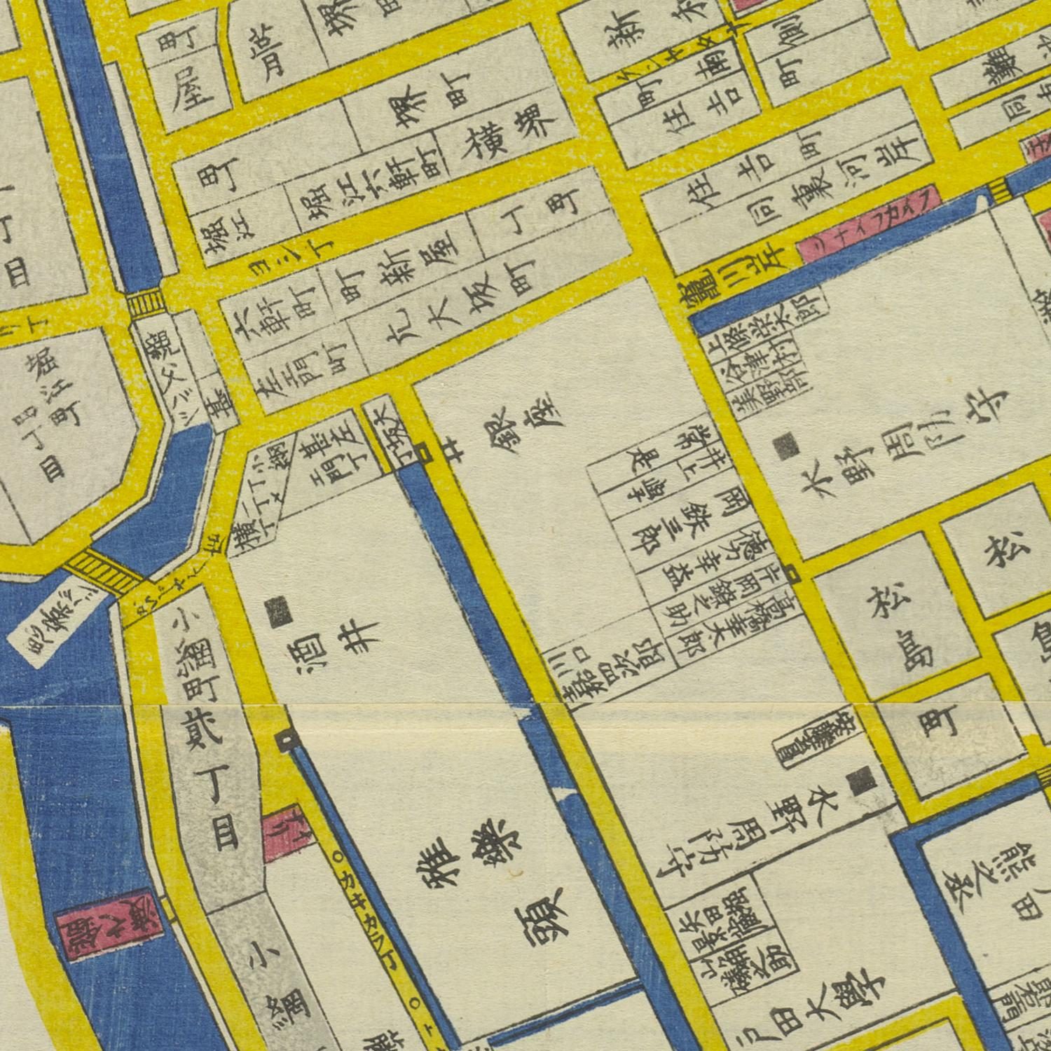 Fig. 4: Kiriezu nihonbashi kita (1852). Original Format: University of British Columbia. Library. Rare Books and Special Collections. G7964.T7 1869 T6 v.1-30 (Click to enlarge, or visit source here). |

Figure 5: Go-funai Enkaku Zusho (1840)(Click to enlarge).
So, why is the neighborhood in the Tōkyō Gōshō Sugoroku listed as Moto-Ōsakachō? The key to unlocking this question lies in the fact that in the decades prior to the scene depicted in the Figure 4 kiriezu, just over 1 acre of land was added to Ginza in the ninth month of 1842. [7] Referring to the 1840 Go-funai enkaku zusho map that allows us to trace changes in Edo land usage patterns, we see that the areas subsumed into Ginza are labeled Moto-Ōsakachō (Figure 5) since Edo was made up of neighborhoods in which one name referred to areas on both sides of the street. But in this case, since one half of the street was subsumed into Ginza, we know that Moto-Ōsakachō only referred to one side of the street. Because the commoner’s district of Moto-Ōsakachō was incorporated into Ginza, the name of Moto-Ōsakachō is listed in the caption on the Tōkyō Gōshō Sugoroku. Thus, the spatial characteristics of the Kawase Gaisha were inherited from the former bukechi. In much the same way, the First National Bank in the centre-top agari square, the Fifth National Bank in the top right square, or the Tokyo Grain Exchange (Tōkyō Shōkō Kaisha) in the right-middle all have the same spatial layout as the Kawase Gaisha. And as we can see in the kiriezu, they all were former bukechi prior to the Meiji Period. In the case of the First National Bank, the Shimada-gumi erected the building in the former compound of the Matsudaira governor of Izumi sold off by the government following the Meiji Restoration.
Next, let’s turn our attention to the rowhouse gates (nagayamon) lining the streets. Nagayamon denotes a rowhouse that includes a gate, a type of construction which for the most part only high-level samurai were permitted to build. In the case of Daimyō, soldiers would live in rowhouses on either side of the gate. In the Kawase Gaisha square on the Tōkyō Gōshō Sugoroku, we can see what at first appears to be a generic nagayamon with a window opening onto the street to the right of the gate. However, there are a number of unexpected things here. First, the gatepost. The gatepost in the image is exceptionally advanced for this time-period. Namely, the top of the pillar is ornamented with a spherical giboshi, a design not formally used for samurai compound gates. Instead, giboshi were a type of ornament seen originally in temple construction and bridge railings. Secondly, the curvature at the top of the gate. Until then, arches and curves were not often seen in a Japan with so much wooden construction. But we can see that the gate of the Kawase Gaisha has an arch with decorations on top. A gate of this same design can also be seen in Tokyo Grain Exchange (Tōkyō Shōkō Kaisha) square in the right-middle of the board. The First National Bank in the agari square also has an arched gate, indicating that such arches were symbols of Western architecture for carpenters at that time.
Although these Western-style buildings all feature arched windows, quoins, and classical entablature, it is clear at first glance that these are not genuine Western buildings. Constructed by Japanese carpenters, the Western-style buildings erected at this time were not made of stone as in the case of actual Western construction but were made of wooden frames and plastered with stone on the outer walls. In other cases, earthen walls were even made to look like stonework. First appearing in the early Meiji Period, this type of so-called “Pseudo-Western” (Giyōfū) architecture was built by Japanese carpenters following the example of Western-style buildings erected in the foreign settlement in Yokohama following the opening of the port in 1854. [8] It was Japanese carpenters employed in the construction of these buildings in the Yokohama foreign settlement who made it possible for Giyōfū architecture to blossom in Tokyo. The first bloom was surely none other than the 1872 First National Bank in the Tōkyō Gōshō Sugoroku’s agari square and popularized by the triptych by Shōsai Ikkei from the same year in Figure 6. The building was a five-story castle-style structure built through and through with Japanese architectural elements, but the bottom two stories were constructed with a design mimicking Western stone architecture. The compound interior, meanwhile, has a courtyard, and the building was divided into a number of small rooms laid out in the Japanese step-back (gankō) style because of its wooden construction, as planned and implemented by Japanese carpenter Shimizu Kisuke. [9]
Figure 6. Ikkei, Kaiunbashi Kawaseza no zu. Source: University of British Columbia. Library. Rare Books and Special Collections. Asian Rare-06 no.L3:9 (Click to enlarge, or visit source here).
While Western-style buildings began to be erected in former samurai areas as hoped for by a Meiji government intent on Westernization, buildings in former commoner areas with the exception of Ginza Bricktown largely remained plaster dozō-zukuri warehouses (for more on Ginza Bricktown, see essay by Tristan Grunow). Looking back from the early Meiji Period to the Edo Period allows us to see continuities in urban space. In the case of the Nihonbashi area, samurai and commoner areas were mixed in the urban space and were often side-by-side. As a result, the Giyōfū buildings of samurai areas and the plaster warehouses of commoner areas, too, were mixed throughout the city. Fires frequently razed commoner areas, with buildings erected only to be consumed by fires time and time again. Finally, in 1881, the Tokyo government issued fireproofing regulations, requiring buildings facing main streets to be built in brick, stone, or plaster. Structures erected following these new guidelines, however, continued to be plaster for the most part. Following the 1872 Ginza Fire and the construction of Ginza Bricktown, Western style buildings gradually began to appear in commoners’ areas. But it was not until the late Meiji Period that Western architecture came to be widespread in commoner areas.
Even still, Western-style buildings erected in the late Meiji period in commoners’ areas were actually wooden, with a façade of plaster made to appear Western. The reason for this was that the people who most actively embraced the impact of “the West” in Tokyo were the skillful merchants who could profit from having a unique Western-style building to attract customers to their stores. As a result, vaguely “Western” streetscapes appeared in downtown areas like Ginza and Asakusa by the end of the Meiji period. The “West” that finally became most familiar to the general public in Tokyo, then, was a “West” that was already a misrepresentation, and it was not even until after the end of the Meiji Period that Western-style rooms began to appear in middle-class Japanese houses. By the 1910s, Western architecture and traditional plaster architecture of various designs chaotically mixed in a state of complete disorder throughout the city. [10]
The Meiji Government erected Western-style buildings to appeal to Western countries in the hopes of revising unequal treaties, requiring the construction of authentic Western architecture. That plan would come to fruition with the Rokumeikan, or “Deer Cry Pavilion,” completed in 1883. In other words, Government-sponsored buildings gradually transitioned from pseudo-Western Giyōfū architecture designed and constructed by Japanese carpenters or hired foreign advisors (oyatoi)[11], to more authentic Western architecture. Urban residents, on the other hand, commissioned Giyōfū-style structures from craftspeople who eagerly embraced Western cultural influences instead of rejecting them. As a result, new techniques adopting new forms without hesitation and allowing new and old forms to coexist began appearing in the urban space of Tokyo. The Tōkyō Gōshō Sugoroku gives us a visual depiction of this mixing of Western and Japanese styles in early Meiji Tokyo.
Translated by Tristan R. Grunow
Buildings and Locations Depicted in the Tōkyō Gōshō Sugoroku:
- Moto-Ōsakachō – Kawase Gaisha
- Yoroibashi – Shimada-gumi
- Shin-izumichō – Enomoto Shōkai (Daikokuya)
- Ōkawabata – Kaisō Gaisha
- Shinkawa – Kajima Sakadana
- Shiodome – Hōraisha
- Surugachō – Mitsui-gumi
- Tōrihatagochō – Daimaru
- Tsukiji – Seiyōken
- Komagome – Takasakiya
- Sanaichō – Rikuun Motokaisha
- Ginza Sanchōme – Ōkura-gumi, Senshū Gaisha
- Kobikichō – Takashima-gumi
- Edobashi – Yūbin Kaisha (Hokkaidō Kaisha)
- Mannenbashi – Sekitan Abura Kaisha
- Asakusa Hirokōji – Basha Kaisha
- Shinagawa-oki – Mitsubishi-gumi
- Kakigarachō 2-chōme – Shōkō Kaisha
- Nihonbashi – Okada Shōkai
- Ginza – Nichi nichi Shinbun
- Kakigarachō 1-chōme – Daigo Kokuritsu Ginkō
- Kaiunbashi – Daiichi Kokuritsu Ginkō
Endnotes:
[1] 加藤康子・松村倫子編著『幕末・明治の絵双六』国書刊行会、2002
[2] 高橋順二編著『日本絵双六集成』柏書房,1980
[3] 東京市役所市史編纂『東京案内上巻』1986(1907年書肆裳華房の復刻版を用いた)、また、東京府が明治5年から7年にわたって行った調査(東京都『東京府史料1』1959)には「大坂の廻船此所まて入津せし故に大坂町と唱う」とある。
[4] 吉田伸之編「江戸の土地—大名・幕臣の土地問題」『日本の近世9』中央公論社,1992
[5] 大石学『地名で読む江戸の町』PHP新書,2001、および[3]
[6] 東京市日本橋区役所編纂『日本橋区史第一册』1916
[7] 東京市日本橋区役所編纂『日本橋区史第三册』1916
[8] 擬洋風建築の解説については藤森照信『日本の近代建築(上)-幕末・明治篇–』岩波新書,1993に詳しい。
[9] 初田亨『都市の明治—路上からの建築史』1981筑摩書房
[10] 前掲[9]
[11] “Hired foreign advisors” (oyatoi) refers to foreigners hired by the Meiji government in the early Meiji period. Many of the foreigners hired relating to architecture were actually engineers rather than architects.
本論を知る上で参考になる資料リスト
・松山恵『江戸・東京の都市史 近代移行期の東京・建築・社会』東京大学出版、2014
・初田亨『繁華街の近代 都市・東京の消費空間』東京大学出版、2004
・吉見俊哉『都市のドラマトゥルギー 東京・盛り場の社会史』弘文堂、1987
・川崎房五郎『都市紀要十三 明治初年の武家地処理問題』東京都、1965
About the Author
 KANAYA Masataka is a PhD Candidate in the Department of Architecture in the Graduate School of Engineering and Design at Hōsei University in Tokyo, Japan.
He specializes in the modern architectural and urban history of Tokyo, and is researching the repurposing of former warrior compounds into cultivated fields in the early Meiji Period, early Meiji urban dairy farming and agriculture, and changes to the urban core and suburbs of Tokyo under Shokusan Kōgyō policies.
「東京豪商寿語六」から読み解く江戸の空間構成
Click here for the English version
金谷 匡高
法政大学
東京豪商寿語六. ブリティッシ
この三代目歌川広重が描いた絵双六は、明治初期の東京の様子を描いた浮世絵である。双六とは、ふりだしの枡目から始まり、さいころを振って上がりの枡目まで相手より先に進んだ方が勝ちとなる遊びである。世界中で似たような遊びが見られ、日本では「絵双六」という印刷物の上で行う双六が広まり、江戸中期の出版技術の発達に伴って様々な種類の物が刊行された。注1)絵双六は種類が非常に多く分類方法も様々であるが、高橋順二氏の『日本絵双六集成』の分類によるならば、「東京豪商寿語六」は明治初期に多く描かれた文明開化の様子を描く開化双六に分類されよう。注2) しかし、そこには、文明開化の象徴である西洋風の建物のすぐ隣に江戸以来の建物が併存して描かれている。このように、近代初期の東京には和洋の建築が同じ都市空間内に混在して建ち並んでいた。都市の西洋化は明治政府主導のもとで始め進められ、明治後半には市民が非日常的な都市空間を体験する場として自ら受容していく。だが、近代初期の東京の街区構造や土地区分は、江戸から受け継いでおり、この都市空間を把握するには、どのような建物がどのような場所に建てられたかを把握することが重要である。この東京豪商寿語六に描かれたものから、明治初期の東京の都市空間を考察したい。
では、詳しく「東京豪商寿語六」をみていきたい。各枡目には、城郭風の建物や屋根の上に鯱が乗る建物、銀座の西洋館など石積みや土蔵の建物が並び現在の東京では見ることが出来ない建物が描かれている。また、それぞれ見出しが付けられ、当時の東京に新しく現れた会社とその所在地が書かれている。始めの枡目は為替会社で、サイコロを振って第一国立銀行まで進むと上がりとなる。まず、為替会社の枡目に目を向けると、説明に元大坂町と書かれている。(Fig.1)元大坂町とは関東大震災の帝都復興事業により1933年に無くなってしまう町名であるが江戸期の町人地である。諸説あるが、天正の頃(1573~1592年)に移住してきた大阪商人の受領地であったことからこの名が付けられ、新大坂町と区別するために元が付いている。注3)江戸時代、江戸の都市空間は主に武家地、町人地、寺社地の3つに区分されていた。明治2(1869)年の調査では、江戸市中の面積の内68.6%、1169万坪を占めていたのが武家地であり、それに対して、町人地が15.8%、寺社地が15.6 %でほとんどを武家地が占めていた。注4) また、それぞれの土地に建つ建物は大まかに類型化する事が出来る。
 Fig.1: 為替会社. (東京豪商寿語六). ブリティッシュ・コロンビア大学図書館貴重史料室Asian Rare-6 no.L3:1. (クリックで画像拡大) |  Fig. 2: 榎本商会. (東京豪商寿語六) .ブリティッシュ・コロンビア大学図書館貴重史料室 Asian Rare-6 no.L3:1. (クリックで画像拡大) |
そこで注目したいのは建物の配置である。街路から門を入り奥まったところに建物が建てられ、正面玄関は前面にある門で隠れてしまい見ることが出来ない。この屋敷配置の特徴は江戸時代の武家地の特徴を踏襲しているといえる。江戸の武家地は徳川幕府から武士に限って与えられた土地であり、その規模は大小様々であるが、基本的な配置は門を街路に面して構え、門をくぐり敷地の中に入る。そして、客を迎える専用の玄関を通り、建物の中へと入っていくという段階制を踏んでいる。それに対して、江戸の町人地は、街路に面して店舗を構えるため、門は構えず街路から直接建物に入ることとなる。絵双六で見れば榎本商会、鹿島酒店などがその典型である。このように、建物の配置を見ることで江戸期の屋敷の類型化が可能となる。だが、為替会社は旧町人地の敷地に武家屋敷の配置をした建物が建てられていたことになる。
さて、為替会社は町人地の元大坂町になぜこのような武家屋敷の配置をしているのか。結論から言えばこの地は元々武家地であったのである。まずは、明治7年の東京全図をみてみよう。中央右上に東京為替会社の記載がある。(Fig.3)左側に隣接する敷地と比較すると非常に大きな敷地であるのが読み取れる。実は、東京為替会社は元大坂町ではなく蛎殻町2丁目にあった。そこで、1859年に刷られた尾張屋板の切絵図をみてみよう。(Fig.4)東京全図で見た位置関係は元大阪町に隣接する南側である。切絵図には「銀座」と書かれている。かつての銀造所であった銀座が、明治になり東京為替会社になったのである。補足すると、現在の銀座という町名がFig.4の銀座よりも南西にあるのは、寛政12(1800)年に、経営の悪化、役人の不正事件を理由に元大坂町の隣に移されたからである。注5)この時、銀造所の銀座は勘定奉行の直轄となる。また、元大坂町と道を挟んだ向かい側一帯は大名屋敷が多く建ち並び、一帯が武家地であった。江戸期の武家地には町名がなく、蛎殻町は明治4年10月に付けられた町名である。注6)では、なぜ元大坂町なのだろうか。その鍵は、この切絵図よりもさかのぼること十数年前、天保13(1842)年9月に銀座は「1287坪を増した」とある。注7)さらに、御府内沿革図書という江戸の土地利用の変遷を追うことができる地図をみると、敷地を増やす直前の銀座周辺が描かれ、銀座が新たに取得した部分には元大坂町と描かれている。(Fig.5)江戸の町割りは道を挟んで両側を一つの単位とする両側町と呼ばれる町を形成していた。それが銀座の屋敷に取り入れられたために、元大坂町は片側だけになってしまったのが分かる。つまり、銀座の一部は、元大坂町の町屋を取得して銀座の敷地としており、そのため元大坂町というキャプションが付けられていた事が考えられる。これまで見てきたように為替会社の空間的特徴は、旧武家地から受け継いだものといえる。そして、同様にみていくと、上がりの第一国立銀行や第五国立銀行、商行会社などは為替会社と同じ屋敷配置をしており、切絵図で確認するとどれも旧武家地が明治に変じた空間であった。第一国立銀行、島田組の建物は松平和泉守の屋敷を維新以降に政府から払い下げられて手に入れた土地であった。
 Fig. 3: 東京全図 (1875) ブリティッシュ・コロンビア大学図書館貴重史料室 G7964 .T7 1875 I3. (クリックで画像拡大) |  Fig. 4: 切絵図日本橋北 (1852) ブリティッシュ・コロンビア大学図書館貴重史料室G7964.T7 1869 T6 v.1-30 (クリックで画像拡大) |
Fig. 5. 御府内沿革図書(1840)
次に、街路に沿って建てられた長屋門にも注目したい。長屋門というのは、主に位の高い武士に許された建築形式のことで、門に長屋が付属した建物のことを指す。大名のものになると門の両側には建物が並び、そこに配下の武士達が居住した。為替会社の門の右側にも道に面して窓が付いていて、一見するとこれも一般的な長屋門に見える。だが、おかしなところが幾つかある。一つ目は、門柱。当時の門柱としては非常に斬新であった。柱の頂部に丸い飾りが付いているが、形式的な武家屋敷の門には用いられないデザインである。これは擬宝珠と呼ばれ、本来は寺院建築や橋の欄干等に使われる装飾である。二つ目は門扉の上部の曲線である。木造建築の日本では、これまでアーチなどの曲線はあまり見られなかった。為替会社の門扉にはアーチが付けられていて、その上には装飾までされていることがわかる。これと同じデザインの門が別の枡目の商行会社にも付いている。上がりの第一国立銀行にもアーチの門が付けられていて、当時の大工にとって西洋建築を表す記号的な意味をもっていたといえよう。
これらの西洋風の建物にはアーチ窓やQuoins、柱頭のEchinus等が付いているが、これらが純粋な西洋建築では無いことは一目でわかる。当時の西洋風建築は日本の大工によって施工されており、実際には石造の西洋建築とは違い、木造で建てられ外壁に石を貼ったものである。また、土壁によって石積みを表現したものまで現れる。明治初期に現れはじめたこのような建築は、大工が横浜にある西洋館を見よう見まねで建てた建築という事で「擬洋風建築」と呼ばれている。注7) 1854年に横浜が開港し、外国人居留地ができるとそこに西洋風建築が建てられていく。それらの工事を請け負っていた日本の大工が、東京にも擬洋風建築の花を咲かせることになる。そのきっかけとなるのが、この双六の上がりで1872(明治5)年に建てられた第一国立銀行であろう(Fig 6)。日本建築の要素がちりばめられ、城郭のような5層の建築であるが、下2層を見ると石造風の西洋建築を模した意匠が施された建物である。注8) しかし、内部には中庭が設けられ、プランも木造建築であるため小さな部屋で分けられた雁行型の日本的なプランであった。これは清水喜助という日本人の大工による設計、施工であった。

Fig 6. 海運橋為換坐之圖 (1872年). ブリティッシュ・コロンビア大学図書館貴重史料室Asian Rare-6 no.L3:1. (クリックで画像拡大)
そして、旧武家地には欧化政策を勧める明治政府の思惑もあり西洋風建築が新たに建てられ始めたが、旧町人地の建物はというと銀座煉瓦街を除きほとんどが土蔵造りであった。このように明治初期の様子を江戸期まで遡りみていくとかつての敷地から継承された都市空間の特徴が見えてくる。今回見た日本橋エリアについて述べると、武家地と町人地は都市空間の中に混在し常に隣り合わせになっていた。それが、明治になり土蔵造りと擬洋風の建築が混在する原因ともなっている。町人地には火災が多く建物が建て込んでいて大火になることが度々あった。1881年に東京府により防火例が出され、主要道路に面する建物は煉瓦造、石造、土蔵に制限された。だが、それにより建て替えられた町屋はほとんどが土蔵造りであったという。明治5年の銀座大火によって計画された銀座煉瓦街建設以降、徐々に町人地にも洋風建築が建てられるようになったが、それは混在していた。明治後期にようやく町人地にも洋風建築が受け入れられるようになる。
しかし、明治後期に町人地に建てられた洋風建築は、木造建築であるがファサードを漆喰で塗り西洋風に見せた表面的なものであった。なぜなら、新たに東京に現れた西洋というインパクトを積極的に取り入れた者たちはそれを巧みに利用した商人たちだったからである。西洋風の珍しい外観が店の看板として機能した。そのため、どこの国ともわからない洋風建築の町並みが、明治後期の銀座や浅草のような繁華街に登場した。こうして、ようやく庶民の中にも西洋が身近なものとなってきたが、それは既に歪曲された西洋であった。さらに付け加えると、庶民の生活内部に西洋が入ってくるのは遅く、住宅に洋間が普及するのは明治も終わりになってからのことである。1910年頃には様々な意匠を凝らした西洋風建築や土蔵建築が入り乱れ「百鬼夜行」の様子とまで言われるようになった。注10)
明治政府によって建てられる西洋建築は、条約改正のための西洋諸国への対外的なアピールであり本格的な西洋建築を建設することが求められた。その計画は鹿鳴館の建設で一応の完成をみる。つまり、政府による西洋建築は、始めは大工や御雇い外国人注11)の設計施工による擬洋風建築であったものから次第に本格的な西洋建築になっていった。それに対して、都市の体験者である民衆は職人による擬洋風建築をその後もどんどんと取り入れていったのだ。これは、職人達が新しく流入した文化を拒絶せず貪欲に吸収していったためともいえよう。新しいものを躊躇なく取り入れ、そして共存させてしまう手法は都市空間にも現れていた。この絵双六はその明治初期日本の西洋と和風が混在している様子を描いた物であるといえよう。
脚注:
[1] 加藤康子・松村倫子編著『幕末・明治の絵双六』国書刊行会,2002
[2] 高橋順二編著『日本絵双六集成』柏書房,1980
[3] 東京市役所市史編纂『東京案内上巻』1986(1907年書肆裳華房の復刻版を用いた)、また、東京府が明治5年から7年にわたって行った調査(東京都『東京府史料1』1959)には「大坂の廻船此所まて入津せし故に大坂町と唱う」とある。
[4] 吉田伸之編「江戸の土地—大名・幕臣の土地問題」『日本の近世9』中央公論社,1992
[5] 大石学『地名で読む江戸の町』PHP新書,2001、および[3]
[6] 東京市日本橋区役所編纂『日本橋区史第一册』1916
[7] 東京市日本橋区役所編纂『日本橋区史第三册』1916
[8] 擬洋風建築の解説については藤森照信『日本の近代建築(上)-幕末・明治篇-』岩波新書,1993に詳しい。
[9] 初田亨『都市の明治—路上からの建築史』筑摩書房,1981
[10] 前掲[9]
[11] 御雇い外国人とは明治初期に明治政府から雇われた外国人技術者たちで、建築を担当した多くの人物がArchitectではなくEngineerであった。
本論を知る上で参考になる資料リスト
・松山恵『江戸・東京の都市史 近代移行期の東京・建築・社会』東京大学出版、2014
・初田亨『繁華街の近代 都市・東京の消費空間』東京大学出版、2004
・吉見俊哉『都市のドラマトゥルギー 東京・盛り場の社会史』弘文堂、1987
・川崎房五郎『都市紀要十三 明治初年の武家地処理問題』東京都、1965
筆者紹介
法政大学デザイン工学研究科建築学専攻 博士後期課程在籍
専門は近代東京の建築史・都市史。研究テーマは、明治初期における武家地の荒廃と耕作地化、明治初期の都市酪農/農業、殖産興業による東京都心/郊外の変化について研究を行う。